How to Build a Satellite Crop Monitoring Platform
Agriculture is becoming one of the most data-intensive industries in the world. Modern farms generate information from satellites, drones, weather stations, IoT sensors, machinery, and field scouting activities. The challenge is no longer collecting data. The challenge is turning that data into decisions that improve crop performance.
Satellite technology has transformed how agricultural businesses monitor fields at scale. The European Space Agency’s Sentinel-2 mission provides multispectral imagery with a revisit frequency of five days and spatial resolutions of up to 10 meters, allowing growers to monitor crop conditions throughout the growing season.
At the same time, drones have made high-resolution crop monitoring more accessible. Unlike satellites, drones can capture imagery on demand and provide detailed field-level views that help identify crop stress, disease outbreaks, weed pressure, emergence issues, and other agronomic challenges. High-resolution drone imagery is increasingly used to support precision agriculture and field scouting activities.
However, imagery alone does not create value.
Most growers are not looking for thousands of images, vegetation maps, or raw sensor readings. They need practical answers to operational questions:
- Which fields require immediate attention?
- Where are crops showing signs of stress?
- Which zones need additional scouting?
- How might weather conditions affect crop development?
- What actions should be taken next?
This is where crop monitoring software becomes essential.
A modern crop monitoring platform combines satellite imagery, drone data, weather information, field observations, and sensor data into a single crop intelligence platform. Instead of presenting raw information, the system analyzes data from multiple sources and delivers actionable insights through alerts, crop health maps, recommendations, and decision-support tools.
As agriculture continues to adopt remote sensing technologies, successful crop monitoring platforms are becoming less focused on imagery itself and more focused on helping growers make faster and better decisions. The real value lies not in collecting data, but in transforming it into operational intelligence that improves productivity, reduces risk, and supports precision agriculture at scale.
How satellite crop monitoring works
Satellite crop monitoring allows agricultural businesses to observe crop conditions across entire fields without physically visiting every location. Modern crop monitoring software uses satellite imagery to identify crop stress, monitor vegetation development, and support agronomic decision-making throughout the growing season.
One of the most widely used satellite programs in agriculture is the Copernicus Sentinel-2 mission. Sentinel-2 consists of Earth observation satellites operated by the European Space Agency (ESA) and provides free access to multispectral imagery for agricultural monitoring. Sentinel-2 captures data across 13 spectral bands and delivers imagery with spatial resolutions of 10, 20, and 60 meters. The satellite constellation can revisit the same location approximately every five days, enabling continuous crop monitoring throughout the season.
Unlike standard aerial photography, Sentinel-2 collects information beyond the visible spectrum. These additional spectral bands allow crop monitoring platforms to analyze plant health, detect vegetation stress, and identify changes that may not be visible to the human eye.
Most crop intelligence platforms process satellite imagery to generate vegetation indices and field performance maps. These indicators help agronomists and growers evaluate crop conditions across large areas.
The most common metrics include:
| Metric | Primary Purpose |
|---|---|
| NDVI | Monitoring crop vigor and vegetation development |
| NDRE | Detecting nitrogen deficiency and chlorophyll activity |
| EVI | Analyzing dense vegetation canopies |
| Soil Moisture Indicators | Supporting irrigation decisions |
| Surface Temperature | Identifying crop stress and water deficits |
Satellite crop monitoring provides several advantages for agricultural businesses:
- Continuous field monitoring throughout the season
- Coverage of large geographic areas
- Early identification of crop stress
- Reduced scouting costs
- Historical field performance analysis
- Improved resource allocation
However, satellite imagery alone rarely provides enough information for operational decision-making. Most modern crop monitoring platforms combine satellite data with drone imagery, weather information, field observations, and sensor data to create a more complete picture of crop performance.
This combination of data sources is what transforms satellite imagery from a visualization tool into a true crop intelligence platform capable of supporting precision agriculture at scale.
Why crop monitoring platforms are becoming essential
Agriculture is becoming more complex every year. Farmers and agribusinesses must manage larger operations, rising production costs, unpredictable weather patterns, and increasing pressure to improve efficiency. At the same time, skilled labor is becoming harder to find in many agricultural regions.
These challenges are driving demand for crop monitoring platforms that provide continuous visibility into field conditions and support data-driven decision-making.
Modern crop monitoring software helps growers monitor thousands of acres more efficiently by combining satellite imagery, drone data, weather information, and field observations into a single crop intelligence platform.
Several industry trends are accelerating adoption.
Labor shortages
Agricultural labor shortages continue to affect farming operations around the world. Fewer workers mean fewer opportunities for manual field inspections and crop scouting.
Crop monitoring platforms help fill this gap by identifying areas that require attention and prioritizing field activities. Instead of inspecting every field, teams can focus on locations where problems are most likely to occur.
Larger farm operations
Farm sizes have increased significantly in many agricultural regions. Managing hundreds or thousands of acres through manual observation is no longer practical.
Satellite crop monitoring allows growers to assess field conditions across large geographic areas from a single dashboard. This improves visibility while reducing the time required for monitoring activities.
Climate variability
Weather patterns are becoming more difficult to predict. Droughts, excessive rainfall, heat stress, and extreme weather events can have a major impact on crop performance.
Crop intelligence platforms help growers detect environmental stress earlier and respond more quickly to changing conditions.
Rising input costs
Fertilizers, crop protection products, fuel, and irrigation expenses represent a significant portion of farm operating costs. Applying inputs uniformly across entire fields often leads to inefficiencies.
Crop monitoring software helps identify specific areas that require intervention, supporting more targeted and efficient resource use.
The growth of precision agriculture
Precision agriculture depends on timely and accurate data. Farmers increasingly rely on digital tools to guide decisions related to planting, irrigation, fertilization, crop protection, and harvest planning.
Crop monitoring platforms provide the information needed to support these decisions throughout the growing season.
Earlier problem detection
One of the greatest benefits of crop monitoring software is the ability to detect issues before they become visible at the field scale.
Satellite and drone imagery can reveal signs of:
- Crop stress
- Nutrient deficiencies
- Disease pressure
- Water management issues
- Pest damage
Early detection allows growers to take corrective action before yield losses become significant.
Better resource allocation
Agricultural resources are limited and often expensive. Crop monitoring platforms help identify where resources will have the greatest impact.
This allows growers to prioritize scouting activities, optimize input applications, and focus labor where it is needed most.
Improved yield potential
Better information often leads to better decisions. By identifying field variability and addressing problems earlier, growers can create conditions that support stronger crop performance.
While no software can guarantee yields, crop intelligence platforms help reduce uncertainty and improve management decisions throughout the season.
Reduced field visits
Field scouting remains important, but it can be time-consuming and expensive. Crop monitoring platforms help reduce unnecessary field visits by highlighting areas that require attention.
This targeted approach improves efficiency while maintaining visibility into crop conditions.
Data-driven decisions
Modern agriculture generates large volumes of information. The challenge is transforming that information into practical actions.
A crop monitoring platform combines multiple data sources into a single decision-support environment. Instead of relying solely on observation or experience, growers can use objective data to support operational decisions.
This shift toward data-driven agriculture is one of the main reasons crop monitoring platforms are becoming a core component of modern farming operations.
How satellite crop monitoring works
Satellite crop monitoring allows agricultural businesses to observe crop conditions across entire fields using Earth observation satellites. Instead of relying solely on field visits, growers can monitor crop development, identify risks, and track changes throughout the growing season from a digital platform.
Modern crop monitoring software processes satellite imagery and transforms it into maps, vegetation indices, alerts, and recommendations that support agronomic decision-making.
Earth observation satellites
Earth observation satellites continuously capture images of the planet’s surface. These satellites collect information from agricultural fields and make it possible to monitor crops across large geographic areas.
Several satellite systems are widely used in agriculture:
- Sentinel-2 — Free multispectral imagery from the European Space Agency’s Copernicus program.
- Landsat — Long-running Earth observation program operated by NASA and the U.S. Geological Survey.
- Planet — Commercial satellite constellation that provides high-frequency imagery with near-daily coverage.
These satellite systems allow crop monitoring platforms to track field conditions throughout the growing season without requiring equipment to be installed in the field.
Multispectral imagery
Satellite crop monitoring relies on multispectral imagery rather than standard photographs.
Traditional images only capture visible light. Multispectral imagery captures additional wavelengths, including near-infrared and shortwave infrared bands. These wavelengths reveal information about plant health that cannot be seen with the naked eye.
Healthy vegetation reflects light differently than stressed vegetation. By analyzing these patterns, crop monitoring software can identify changes in crop conditions before symptoms become visually obvious.
Vegetation indices
Most crop intelligence platforms use vegetation indices to simplify the analysis of satellite imagery.
A vegetation index is a mathematical calculation that combines data from different spectral bands to measure specific crop characteristics.
These indices help agronomists and growers quickly identify trends, compare fields, and detect potential problems.
Field monitoring through satellite data
Satellite crop monitoring enables continuous observation of agricultural fields throughout the season.
Growers can use satellite data to:
- Monitor crop growth stages
- Detect crop stress
- Evaluate field variability
- Identify areas requiring scouting
- Track irrigation performance
- Assess the impact of weather events
Instead of inspecting every acre manually, teams can focus their attention on the locations where intervention is most likely to be needed.
How drone agriculture software complements satellite data
Satellite monitoring has become a powerful tool for precision agriculture, but it is not designed to solve every monitoring challenge. While satellites provide excellent coverage of large agricultural areas, they also have limitations that can affect the quality and timing of insights.
This is why many modern crop monitoring platforms combine satellite crop monitoring with drone agriculture software. Together, these technologies provide both broad field visibility and detailed field-level analysis.
Limitations of satellite crop monitoring
Satellites are highly effective for monitoring large farming operations, but several factors can limit their usefulness in certain situations.
Cloud cover
Optical satellites cannot see through clouds. During periods of frequent cloud cover, growers may experience delays in receiving usable imagery. This can be particularly challenging during critical crop growth stages when timely information is needed.
Lower resolution
Satellite imagery is designed to cover large areas. While it can identify field-level trends, it may not capture small-scale issues affecting individual rows, plants, or management zones.
Many crop problems begin at a much smaller scale than satellites can reliably detect.
Fixed revisit schedules
Satellites follow predetermined orbits. Even with modern satellite constellations, imagery is only available when the satellite passes over the area and weather conditions allow for image capture.
Growers cannot schedule a satellite image exactly when they need it.
Advantages of drone agriculture software
Drones help address many of these limitations by providing flexible, high-resolution imagery on demand.
Instead of waiting for the next satellite pass, growers can deploy drones whenever field conditions require additional investigation.
On-demand imagery
Drone flights can be scheduled at specific times and locations.
This allows agronomists and farm managers to collect data immediately after weather events, during disease outbreaks, or whenever unusual field conditions are detected.
Centimeter-level resolution
One of the biggest advantages of drone agriculture software is image quality.
While satellite imagery typically measures resolution in meters, drones can capture imagery with centimeter-level detail. This makes it possible to identify issues that would be impossible to detect using satellite data alone.
Detailed crop inspections
Drone imagery provides a close-up view of crop conditions across entire fields.
Rather than replacing field scouting, drones help direct scouting efforts to the areas where intervention is most likely to be needed.
Common applications of drone agriculture software
Modern crop intelligence platforms use drone data for a wide range of agronomic applications.
- Stand counts. Drone imagery can be used to estimate plant populations and evaluate planting performance shortly after emergence. This helps growers identify gaps, uneven emergence, and replanting requirements.
- Disease detection. High-resolution imagery allows crop monitoring software to identify disease symptoms and stress patterns across large areas. Early detection supports faster intervention and helps reduce potential yield losses.
- Weed identification. Drones can help locate weed infestations before they spread throughout a field. This information supports targeted crop protection strategies and more efficient use of herbicides.
- Emergence analysis. Monitoring crop emergence is critical during the early stages of the growing season. Drone imagery provides detailed visibility into stand establishment, helping growers assess crop development and identify areas with poor emergence.
- Damage assessment. Drones are frequently used to evaluate crop damage caused by storms, flooding, drought, pests, wildlife, or machinery. High-resolution imagery helps quantify the extent of damage and supports insurance claims, agronomic planning, and recovery efforts.
- Combining satellite and drone data. The most advanced crop monitoring software uses satellite and drone imagery together rather than treating them as competing technologies. Satellite data provides continuous monitoring across large areas and helps identify potential problem zones. Drone agriculture software then provides the detailed imagery needed to investigate those areas and support field-level decisions.This combination allows crop intelligence platforms to deliver both scale and precision, creating a more complete understanding of crop performance throughout the growing season.
Challenges of building a crop monitoring platform
Building a crop monitoring platform involves much more than displaying satellite maps or drone imagery. Behind every crop health map, alert, or recommendation is a complex system responsible for collecting, processing, analyzing, and delivering large volumes of agricultural data.
As crop intelligence platforms become more advanced, several technical and operational challenges must be addressed to ensure reliability, accuracy, and scalability.
Managing large volumes of imagery
Satellite and drone imagery can generate enormous amounts of data. A single drone flight may produce hundreds or thousands of images. Large agricultural operations can accumulate terabytes of imagery over multiple growing seasons. Crop monitoring software must be able to store, process, organize, and retrieve this information efficiently without affecting performance. Data storage strategies, cloud infrastructure, and image processing pipelines become critical components of platform architecture.
Geospatial data processing
Agricultural imagery is only useful when it can be accurately linked to real-world locations.
Crop monitoring platforms must process geospatial data from multiple sources while maintaining consistency across fields, farms, and growing regions.
This often includes:
- Field boundary management
- Map projections and coordinate systems
- Image alignment
- Georeferencing
- Spatial analytics
Poor geospatial processing can lead to inaccurate recommendations and unreliable insights.
Satellite data quality
Satellite imagery is a valuable source of agricultural intelligence, but it is not always perfect.
Several factors can affect image quality:
- Cloud cover
- Atmospheric conditions
- Shadows
- Data gaps
- Resolution limitations
A crop monitoring platform must be capable of identifying poor-quality imagery and compensating for missing or incomplete data when possible. Many platforms use multiple satellite sources to improve reliability and increase monitoring frequency.
Drone data standardization
Drone operations often involve different aircraft, cameras, sensors, and software tools. As a result, imagery collected from different drone systems may vary significantly in quality, format, and metadata.
To ensure consistent analysis, crop monitoring software must standardize incoming drone data before it enters the analytics workflow. Without proper standardization, comparisons across flights, seasons, and locations become difficult.
Integrating multiple data sources
One of the biggest challenges in crop monitoring platform development is data integration.
Modern agricultural intelligence platforms rarely rely on imagery alone. They often combine information from:
- Satellites
- Drones
- Weather services
- IoT sensors
- Farm management software
- Machinery telematics systems
- Agronomic records
Each source may use different formats, update frequencies, and communication protocols. Creating a unified agronomic data layer that combines these systems into a single operational environment is often more difficult than building the analytics itself.
Mobile performance in rural areas
Many crop monitoring platforms are used in locations with limited internet connectivity.
Agronomists, crop advisors, and farm managers frequently need access to maps, recommendations, and field records while working in remote areas.
This creates several requirements:
- Fast mobile performance
- Offline functionality
- Efficient data synchronization
- Low bandwidth consumption
A platform that performs well in an office environment may become unusable in the field if these requirements are not considered during development.
Scalability
Many crop monitoring projects begin with a small number of fields and users. However, successful platforms often grow rapidly.
As adoption increases, the platform must be able to handle:
- More imagery
- More users
- More farms
- More integrations
- More analytical models
Scalability must be considered from the beginning. Rebuilding core architecture after rapid growth can become expensive and disruptive. For this reason, many organizations choose cloud-native architectures that allow the crop monitoring platform to scale as data volumes and business requirements evolve.
Why these challenges matter
The success of a crop monitoring platform depends not only on its user interface or analytical capabilities, but also on the quality of its underlying architecture.
Organizations that address data management, geospatial processing, integrations, mobile performance, and scalability early in the development process are more likely to build crop intelligence platforms that deliver long-term business value.
In many projects, the greatest challenge is not generating insights from satellite and drone data. It is creating a reliable system that transforms diverse agricultural data sources into actionable recommendations that users can trust.
Crop monitoring platform development cost
The cost of crop monitoring platform development depends on several factors, including the complexity of data processing, the number of integrations, analytical capabilities, and scalability requirements.
A simple platform that displays satellite imagery and field boundaries can be developed relatively quickly. However, costs increase significantly when organizations add drone processing, artificial intelligence, geospatial analytics, mobile applications, and integrations with external agricultural systems.
The table below provides general cost ranges for different types of crop monitoring software projects.
| Platform Scope | Estimated Development Cost |
|---|---|
| MVP Crop Monitoring Platform | $30,000–$80,000 |
| Commercial Crop Monitoring Platform | $80,000–$250,000 |
| Enterprise Crop Intelligence Platform | $250,000–$1M+ |
MVP crop monitoring platform
An MVP, or Minimum Viable Product, focuses on validating a business idea and delivering core functionality.
Typical MVP features include:
- Satellite imagery integration
- Field boundary management
- Basic crop health maps
- User management
- Simple dashboards
- Mobile-responsive interface
This approach is common among AgTech startups looking to enter the market quickly while minimizing initial investment.
Commercial crop monitoring platform
A commercial platform typically supports active customers and larger operational workflows.
Additional capabilities often include:
- Multiple satellite providers
- Drone imagery processing
- Mobile applications
- Alerts and notifications
- Historical analytics
- Weather integrations
- Agronomic reporting
At this stage, the platform begins to function as a complete crop intelligence solution rather than a monitoring tool alone.
Enterprise crop intelligence platform
Enterprise-grade platforms support large agricultural organizations, cooperatives, food companies, insurers, and agricultural service providers.
These systems often include:
- AI-powered analytics
- Yield forecasting models
- Geospatial processing pipelines
- Multi-tenant architecture
- Advanced security controls
- ERP and farm management integrations
- Carbon and sustainability reporting
- Large-scale data processing infrastructure
Enterprise platforms are designed to support thousands of users, millions of acres, and multiple data sources simultaneously.
Key factors that influence development cost
The scope of the platform is only one part of the equation. Several technical factors can significantly affect the final budget.
- Number of Integrations. Modern crop monitoring platforms rarely operate as standalone systems. Integrations with farm management software, weather providers, satellite services, drone platforms, machinery telematics systems, and ERP solutions can account for a substantial portion of development effort. The more systems that need to communicate with each other, the more complex the project becomes.
- AI and Machine Learning Models. Artificial intelligence capabilities can increase development costs considerably. Examples include: disease detection, yield prediction, crop stress analysis, weed identification, irrigation recommendations
- Drone Data Processing. Drone imagery introduces another layer of complexity. A crop monitoring platform may need to support: image stitching, orthomosaic generation, georeferencing, high-resolution image storage, computer vision processing. These workflows often require significant computing resources and specialized geospatial tools.
- Geospatial Infrastructure. Geospatial processing is one of the most important components of crop intelligence platform development.
- Features such as field boundary management, map rendering, vegetation index generation, spatial analytics, and historical field comparisons require dedicated geospatial infrastructure. As platform usage grows, these services must scale efficiently while maintaining performance.
- User Volume and Scalability. The number of users, farms, and monitored acres directly affects infrastructure requirements. A platform supporting a few hundred users has very different architecture requirements than a platform serving agricultural enterprises across multiple regions. Scalable cloud infrastructure, data storage, and analytics pipelines become increasingly important as adoption grows.
How Qaltivate builds crop monitoring platforms
Building a successful crop monitoring platform requires more than connecting satellite imagery and displaying maps. The real challenge is transforming large volumes of agricultural data into practical insights that support daily decision-making.
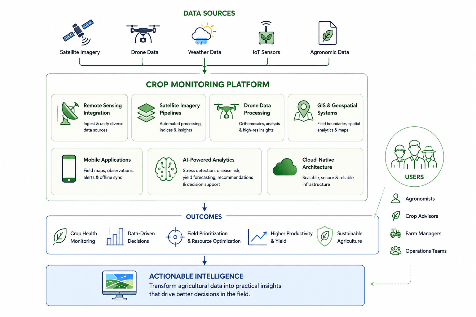
At Qaltivate, we develop crop monitoring software and agricultural intelligence platforms that combine remote sensing technologies, geospatial analytics, artificial intelligence, and field workflows into a single operational ecosystem.
- Remote sensing integration. Modern crop monitoring platforms rely on multiple sources of agricultural data. We help organizations integrate satellite imagery, drone data, weather services, IoT devices, and agronomic datasets into a unified platform. This approach eliminates data silos and creates a more complete view of crop performance across fields and growing seasons.
- Satellite imagery pipelines. Satellite data is only valuable when it can be processed efficiently and delivered in a usable format. Our team develops automated satellite imagery pipelines that collect, process, and analyze data from Earth observation sources. These pipelines generate crop health maps, vegetation indices, field performance insights, and historical analytics that support precision agriculture initiatives.
- Drone data processing. Drone imagery provides a level of detail that satellite monitoring alone cannot achieve. We build systems that support drone image ingestion, orthomosaic generation, geospatial processing, and high-resolution field analysis. This enables growers and agronomists to investigate crop conditions at the plant and field level while maintaining visibility across larger operations.
- GIS and geospatial systems. Geospatial intelligence is the foundation of every crop monitoring platform. Qaltivate develops GIS-enabled solutions that support field boundary management, spatial analytics, map visualization, historical comparisons, and geospatial data processing. These capabilities help agricultural businesses transform location-based information into actionable insights.
- Mobile applications for field operations. Crop monitoring platforms must be accessible where decisions are made — in the field. We build mobile applications that allow agronomists, crop advisors, and farm managers to access crop health maps, record observations, receive alerts, and synchronize field data directly from remote locations. Offline functionality and efficient synchronization are key parts of our approach.
- AI-powered analytics. Agricultural businesses need more than data visualization. They need guidance on what actions to take next. We develop AI-powered analytics capabilities that support: crop stress detection, disease risk identification, yield forecasting, field prioritization, irrigation recommendations, agronomic decision support. These capabilities help transform raw agricultural data into operational intelligence.
- Cloud-native architecture. Crop monitoring platforms must be able to process growing volumes of imagery, geospatial data, and user activity. Qaltivate designs cloud-native architectures that support scalability, reliability, and long-term growth. Our solutions leverage modern cloud technologies to handle complex analytics workflows while maintaining performance and security.