
Field mapping software
Project Overview
Sproot is a digital agritech platform designed to digitize and streamline outgrower and contract farming operations, primarily across Africa. The mobile application is a critical component of Sproot’s field operations platform, designed for field officers and agribusiness teams to work directly in rural environments. A key capability required by Sproot was the ability for users to capture accurate field boundary data even when offline, given that many operational areas lack reliable connectivity. Qaltivate’s development team was engaged to build this core feature and support other mobile functionality enhancements, ensuring a seamless and productive user experience on device.
Challenge
Sproot operates in the same reality as many agribusiness platforms and field-operations products: critical data is collected in environments where connectivity, hardware, and working conditions are far from ideal. Building reliable digital workflows for these conditions introduces a set of recurring challenges faced by AgTech, FoodTech, and field-service software providers.
Unreliable connectivity in operational environments
Field officers and farmers often work in rural or remote areas with limited or no internet access. For platforms that depend on accurate field data, this creates a structural problem: core workflows must function fully offline without compromising data quality, user experience, or later synchronization. Many products struggle to move beyond “best effort” offline support into true offline-first operations.
Data quality and trust in field-collected geospatial data
Field boundaries are not just visual assets; they are the foundation for planning, input allocation, compliance, yield analysis, and reporting. Poor GPS accuracy, noisy traces, or inconsistent capture processes lead to unreliable data that propagates errors across the entire system. Without built-in validation and quality controls, organizations face ongoing data correction costs and reduced trust in their own platforms.
Mobile performance and device limitations
Field applications must operate on mid-range devices, often under challenging conditions such as heat, glare, limited battery life, and intermittent GPS signal quality. Real-time location tracking, geometry processing, and map rendering place significant demands on mobile performance. Without careful engineering, these features become slow, unstable, or unreliable at scale.
Scalability and maintainability of geospatial workflows
Sproot needed a solution that addressed these challenges holistically: reliable offline operation, controlled data quality, intuitive field workflows, and production-grade mobile performance — all while fitting into a scalable product architecture. Qaltivate was engaged to design and deliver this capability as part of a broader mobile platform evolution.
Solutions
Qaltivate provided a dedicated mobile engineering team that worked as an extension of Sproot’s product and development organization. The engagement focused not only on delivering offline field boundary mapping, but on establishing a robust, scalable approach to building field-ready, offline-first mobile workflows.
Offline-first workflow architecture
Qaltivate designed the mapping functionality around an offline-first principle. All critical operations — location capture, path tracking, geometry processing, and data storage — run locally on the device without relying on continuous connectivity. Data is persisted on-device and synchronized when a network connection becomes available. This approach ensures uninterrupted field operations and predictable user experience in rural environments.
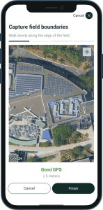
Controlled data quality through built-in validation
To address the common problem of unreliable field data, Qaltivate implemented real-time GPS accuracy monitoring and validation rules. The application only allows boundary capture when location accuracy meets defined thresholds, reducing the risk of collecting low-quality data. This shifts data quality control from back-office correction to the point of capture, lowering long-term operational costs and increasing trust in the dataset.
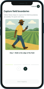
Guided, task-oriented user experience
The user workflow was designed around the realities of field work. Instead of exposing technical mapping tools, Qaltivate implemented a guided, step-by-step process that leads users through preparation, capture, review, and confirmation. This reduces training requirements, improves consistency across teams, and increases adoption among non-technical users.
On-device geometry processing and optimization
Qaltivate implemented on-device geometry simplification using proven algorithms to reduce GPS noise while preserving the essential shape of the field boundary. This improves performance, reduces data payload size, and produces cleaner, more usable geospatial data for downstream systems such as planning, analytics, and reporting.
Production-grade mobile performance
The solution was engineered to perform reliably on mid-range Android devices commonly used in the field. Map rendering, real-time tracking, and data processing were optimized for stability and responsiveness, ensuring the feature remains usable in demanding physical and technical conditions.
Results
The delivery of offline field boundary mapping and the supporting mobile improvements produced measurable operational and product-level impact for Sproot, while establishing a scalable foundation for future geospatial and field-data workflows.
Reliable field operations in low-connectivity environments
Field teams can now execute critical data collection workflows without dependence on network availability. This removes a structural bottleneck common to rural and remote operations and enables consistent, predictable field execution regardless of connectivity conditions.
Improved data quality at the point of capture
By introducing GPS accuracy validation and controlled capture workflows, Sproot significantly reduced the volume of low-quality or noisy geospatial data entering the system. This improves the reliability of downstream processes such as planning, input allocation, reporting, and analytics, and lowers long-term data correction and support costs.
Stronger mobile platform stability and performance
Beyond the mapping feature itself, the improvements to mobile performance and stability increased overall product reliability in real-world field conditions. This is critical for platforms where mobile applications are the primary operational interface.
Scalable foundation for geospatial and field-data workflows
The architecture and implementation approach enables Sproot to extend the platform with additional capabilities such as advanced field analytics, compliance workflows, agronomic recommendations, and more sophisticated geospatial processing without reworking the core data capture pipeline.
Technologies: GIS, Postgis, Google Earth Engine API, Python, GCP, React.js
Team: Project Manager, 2 Software Developers, DevOps, QA Engineer
Services Provided: Mobile App Development, QA, AgTech Software Development, Team Augmentation, Product Engineering, Platform Engineering, Architecture Engineering
